
Silk Road Trade & Travel Encyclopedia
丝绸之路网站(丝路网站)
丝绸之路百科全书—游客、学生和教师的参考资源
İPEK YOLU
ve YOLLARI
ANSİKLOPEDİSİ
www.ipekyollari.net
G
A B
C
D
E
F
G
H I
J
K
L
M
N O P
Q
R
S
T
U V
W
X
Y
Z
Gama
Vasco da Gama (c. 1460 – 1524) was a
Portuguese explorer, one of the most successful explorers of the European
Age of Discovery and the commander of the first ships to sail directly from
Europe to
India. In 1497,
Vasco da Gama led a fleet of four ships from Lisbon, traveled around Africa to
India, and returned. It was with during the Age of Discovery that Europe began
shifting trade with Eurasia to seafaring vessels, causing a decrease of trade
along the network of Silk Routes.
Gandhara (Northwest Pakistan) was once the centre of the
Kushana empire. The language in use in the
Kushana
empire, and derived from Sanskrit, is known as Gandhari. Manuscripts in Gandhari,
written in the Kharosthi script, have been found in modern Afghanistan and
Central Asia (the Kharosthi script was used in the writing of documents in the
Gandhari language, but unlike Brahmi, it did not survive or develop into other
scripts). The style of Buddhist art which developed in this region, influenced
by Hellenistic models, is known as Gandharan. (Click
here to see a map showing the location of Gandhara.)
East-West
cultural exchanges are often said to be well reflected in the sculptural styles
of Gandhara (as well as in Gaul, France) due to the influences that are evident
of the Hellenistic styles that were popularized by the Romans. The ancient
Kingdom of Gandhara lasted from early 1st millennium BC to the 11th century AD,
and played an important role in the transmission of Buddhism along the Silk
Routes. Gandhara is the name of an ancient kingdom (Mahajanapada),
located in northern Pakistan and eastern Afghanistan. Gandhara was located
mainly in the vale of Peshawar, the Potohar plateau (see Taxila) and on the
Kabul River. Its main cities were Purushapura (modern Peshawar), literally
meaning City of Man and Takshashila (modern Taxila).
More...
Gansu province situated upon the Silk Road was an
economically important region located in northwestern China, whose capital is
Lanzhou. The province lies between Qinghai-Tibet and Inner Mongolia and rises
4,921 feet above sea level. To the west of Lanzhou, and west of the Yellow
River, is the famous "Hexi Corridor," an important strategic passage on the
ancient Silk Road stretching to the west. As merchants traveled across the
routes they would go to Dunhuang
in Gansu, where they would get fresh camels, food and guards for the journey
around the dangerous
Taklamakan Desert. The
Mogao
Caves ('Caves of the Thousand Buddhas'),
Maijishan Caves, and the
Bingling Grottoes are
located in Gansu province. Gansu is known as a cultural transmission path, where
an early form of paper inscribed with
Chinese characters and dating to about 8 BC was discovered at the site of a
Western Han
garrison near the Yumen pass.
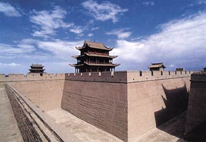
Gansu Jiayuguan Pass
Gansu Corridor (See "Hexi Corridor," and Jiayuguan
Pass) an important strategic passage on the Silk Road.
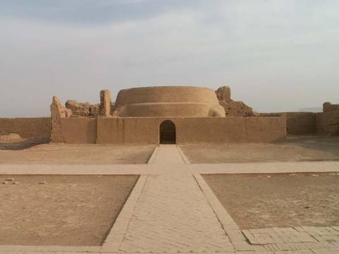
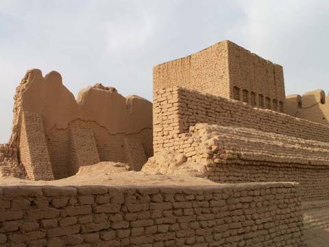
Gaochang (Kocho, Qocho, Karahoca) After the disintegration of the Uighur
Empire (744-840) located north of the Gobi Desert, the Uighurs created the kingdom
of Kocho (Gaochang, c. 860-1284), whose urban centers were in the Turfan
oasis north of the Taklamakan Desert, astride the northern branch of the
Silk Road.
The Uighurs, who
are a Turkic peoples, have for centuries inhabited ancient
oasis
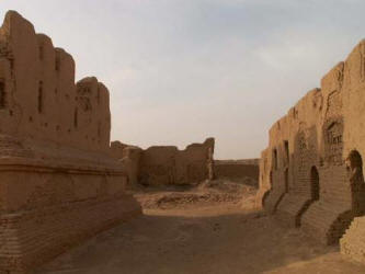
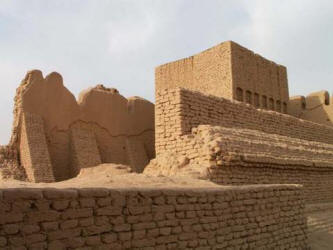
cities ringing the Taklamakan Desert of what is now Xinjiang, China. Gaochang is the site of
such an ancient oasis city that was built
on the northern rim of the inhospitable
Taklamakan Desert. A busy trading center, and near the city of Beshbalik, it was a stopping point for
merchant traders traveling on the Silk Road. The ruins of Gaochang are located
at the foot of the Flaming Mountain, about 40 kilometers southeast of
Turpan.
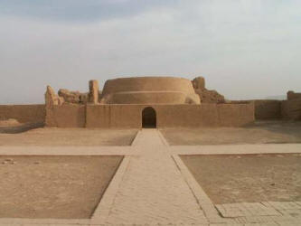
Gaochang,
the ancient Uyghur capital, was also once a
capital of the Han.
The Han Dynasty
garrisoned troops in the city after the 1st century. The city later served as a
capital of the Han Qu family
Kingdom.
In the 10th century, after
the eastward spread of Islam, Islam was established at the Silk Road city of
Kashgar under the Uyghur kingdom. For centuries, Uyghur and Muslim merchants
were renowned as traders in these Silk Road oasis towns. The strategic
importance of these oasis markets enabled many Uyghur traders to become key
middlemen on the Silk Road caravan routes between the Orient and Europe. The
ancient Silk Road, after entering Xinjiang, split into 3 routes, north, middle
and south. Many ruins of ancient cities, watchtowers and numerous historical
sites remain along the routes. Among the important cities and towns are Urumqi,
Turpan (where the ruins of Gaochang city are located), Kashgar, Kuqa Hotan, and
Taxkorgan. (See Beshbalik, Karabalghasun) More...
Gaziantep (Antep, Southeastern Turkey) is amongst the
oldest continually inhabited cities in the world. The history of the
city of Gaziantep dates back to c. to 4000 BC. Many ancient
civilizations were founded in the surrounding regions. The province and
city are located between the Mediterranean Sea and the Mesopotamian
region, which is widely considered to be a
cradle of civilization.
Its strategic location placed the city at the center of historic
crossroads, connecting east to south and north to west, and along the
Silk Road. The province of Gaziantep contains structures and artifacts
from the following periods and civilizations: Paleolithic, Neolithic, Chalcolithic Copper Age, Bronze Age, Hittite, Median, Assyrian, Persian,
Hellenistic (Alexander the Great), Roman, Byzantine, Abbasid and Seljuk.
Genghis Khan (or Chinggis Khaan, Cengiz Han, Cinggis-Qan, c. 1162-1227) was born
named Temujin in Mongolia (Deliun Boldaq) and was the
founder of the Mongol Empire, an empire which became the largest
contiguous empire in history after his death. Genghis Khan created a
unified empire from the nomadic tribes of northeast Asia and promoted
religious tolerance. Before Genghis Khan died, he assigned Ögedei Khan
as his successor and split his empire into khanates among his sons and
grandsons. He died in 1227 after defeating the Tanguts. He was buried in
an unmarked grave in Mongolia. His descendants went on to stretch the
Mongol Empire across most of Eurasia by conquering and/or creating
vassal states out of all of modern-day China, Korea, the Caucasus,
Central Asian, and substantial portions of modern Eastern Europe and the
Middle East.
By the middle of the 13th century, under the leadership of
Genghis Khan, the Mongols controlled Asia from the coast of China to the Black
Sea and west to the Mediterranean (the large sea located between Europe,
northern Africa and southwestern Asia). After Genghis Khan's death, the
Mongol Empire (1206-1368) was led by Kublai Khan who completed the
conquest of China and established the Yuan Dynasty between 1271-1368.
The unified Mongol Empire enabled the Silk Road to remain an important
means of trade and communication. It was during this period European
travelers arrived in China, and as a result of Kublai Khan's tolerance
of religious diversity, a wide range of people settled in China and
along major cities of the Silk Road.
The conquests of
Genghis Khan and his successors effectively connected the
Eastern world with the
Western world, ruling a territory from Southeast Asia to
Eastern Europe. The Silk Road, which connected trade centers
across Asia and Europe, came under the sole rule of the Mongol
Empire. Security and stability was provided along the Silk
Routes in the middle of the 13th century when the family of
Genghis Khan controlled Asia from the coast of China to the
Black Sea. This period with the Mongols in charge of safe routes
is described as
Pax
Mongolica. The end of the Pax Mongolica was marked by
political fragmentation of the Mongol Empire and the outbreak of
the Black Death in Asia which spread along the trade routes to
much of the world. (See Mongolia)
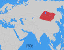
Map of Expansion
Genoa An Italian city-state which traded with Silk Routes
empires. Genoa enjoyed a treaty with the Ilqanate Empire, was involved
in the Crimea and the Byzantine Empire.
Ger (Yurt) Mongol tent.
Gibraltar is located off the southwestern coast of Spain (at
the tip of Europe on
the Iberian
Peninsula) and north of Morocco, located on the North African coast.
Andalusia has figured prominently in the history of Europe and the
Mediterranean due to its links to the
trade routes between
Europe and North Africa.
Gibraltar is the
Spanish derivation of the
Arabic name Jabal Tāriq (جبل طارق), meaning "mountain of
Tariq." It refers to the geological formation, the
Rock of
Gibraltar, which in turn was named after the
Berber
Umayyad general
Tariq ibn-Ziyad who led the initial incursion
into Iberia in advance of the main Moorish force in 711 under the
command of Umayyad Caliph
Al-Walid I. (See
Andalusia) More...
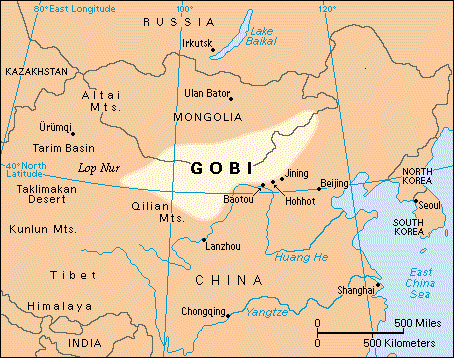
Gobi Desert (Mongolia and China) The most well known
desert of the Silk Road is the
Gobi Desert. This desert is the fifth largest in the world. To the west of the
Gobi Desert in China is the
Taklamakan
Desert, Tarim
Basin and Lop Nur (from where northern and southern
routes would bypass the Taklamakan Desert and Lop Nur). Ancient caravan
trails also passed from Mongolia (i.e. Bayanhongor aimag) across the
Gobi Desert to link up with the Silk Routes of China.
More...
In the early 1920′s, the explorer Roy Chapman Andrews led a team from
the American Museum of Natural History in New York to explore the
Flaming Cliffs and other sites of the Gobi Desert in
Mongolia. They stumbled onto the world's mightiest dinosaur find and the
first known dinosaur nest. While serving as chief of the division of
Asiatic exploration of the American Museum of Natural History, he led
three expeditions, to Tibet, southwest China, and Burma (1916–17);
northern China and Outer Mongolia (1919); and Central Asia
(1921–22 and 1925).
The modern-day paleontologist
and explorer Dr. Mark Norell, Chairman and Curator of
the Division of Paleontology at the American Museum of Natural History,
made further finds in the Gobi when he discovered new
"feathered" dinosaurs from Liaoning, China, and explored
the first indication of a dinosaur nesting on a clutch of eggs like a
bird. Dr. Norell has named numerous dinosaurs which were previously
unknown. In addition to his scientific expeditions, a Silk
Road exhibit was organized by Norell in 2009 at the American Museum
of Natural History, presented in his book "Traveling
the Silk Road: Ancient Pathway to the Modern World," coauthored
by Denise Patry Leidy, Curator of Asian Art at the Metropolitan Museum
of Art (Leidy has also organized a Silk Road related exhibit "The
World of Khubilai Khan: Chinese Art in the Yuan Dynasty" at the
Metropolitan Museum of Art in 2010.)
Gobi Desert & Silk Road Trivia (courtesy
of the American Museum of Natural History)
• People often traveled at night to
avoid scorching desert heat.
• Both one-humped and two-humped camels hauled goods. Camel humps do
not store water, but store fat which provides energy.
• Merchants sometimes packed melons and other fruit in lead containers
filled with snow and ice from mountains before sending them along the
Silk Road.
• When glass first reached China, it was treated as the rarest of
jewels.
• The "Arabic" numerals used today in the West were based on
an Indian system and popularized by an Islamic mathematician in the
early 800s.
Goes
Benedict Goës (Bento de Góis, 1562-1607) Inspired by Marco Polo's writings of a Christian kingdom in
the east, travelled 4,000 miles (6,437 km) in three years across Central Asia.
He never found the kingdom, but ended his travels at the
Great Wall of China in 1605, proving that Cathay was what
the famous Jesuit missionary
Matteo
Ricci (1552–1610) called "China." A missionary and explorer, he is
mainly remembered as the first known European to travel overland from
India to China, via
Afghanistan and the
Pamirs. In 1594 the Portuguese Jesuit Benedict
Goës joined a mission to the Mughal Emperor Akbar, where he was chosen
by the Jesuit leadership (partly because of his knowledge of Persian) to
travel on an exploratory mission to China via Kashgar. He died before
reaching Beijing. What survived of his notes and letters and some oral
accounts were later (1615) combined by the famous Jesuit missionary Matteo Ricci into his travel journal. Despite some inconsistencies and
problems in dating, the account is a unique record by a European of
travel on the overland trade routes in inner Asia at the beginning of
the seventeenth century. The route entails heading northwest into
Afghanistan before going north across the Hindu Kush to the headwaters
of the Amu Darya, then east to Sarikol, and on to Yarkand and Kashgar,
before skirting the Taklamakan on the north. The account details human
and natural threats to travel and other aspects of inner Asian
trade, and provides some valuable information on the political divisions
of the time. More...
Göktürks (or Kök Türks) The first Turkic peoples to
form a state in Central Asia were the Göktürks. Known in medieval
Chinese sources as Tujue (突厥 tú jué), the Göktürks under the leadership
of
Bumin Qaghan
(d. 552) and his sons established the first known Turkic state around
552. The first kingdom to emerge from the Göktürk Khanate gave birth to
the
Uyghur Empire, which flourished in the territory encompassing most of
Central Asia from 744 to 840 AD. This powerful Eurasian nomadic
confederation of medieval
Inner Asia became a main power in Eurasia,
taking hold of the lucrative
Silk
Road trade.

The Turkic Khaganate in its earliest years
After the Turkic
tribes united, the entire area of the Eurasian steppes and the lands of ancient
settled civilizations were also united. Turkic peoples and Sogdian merchants coordinated
with Byzantine traders in the organization of trade from China to the
Mediterranean. The growth of cities also revived trade in China and Iran
(between 627-647 nearly a dozen trade embassies were sent to China). It
was during the 5th–8th centuries that the Silk Routes reached the peak
of their development. Sogdians built cities, palaces, temples, and created
works of art that included paintings and architecture. Trade stations
and settlements of Sogdian merchants, handicraftsmen and farmers in the
6th - 8th centuries extended to the northeast areas of Central Asia,
Xinjiang, Southern Siberia, Mongolia, northern China, and in the west to
the Crimea. The third significant period in the history of the Silk Road
came at the end of the 8th to the beginning of the 13th centuries -- a
period that saw Arab conquests and scientific exchanges.
More...
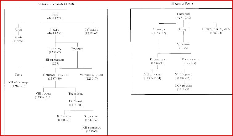
Golden Horde (Khanate of Qipchaq) Russian name for the Mongol domains of Russia and
neighboring areas. The "Great Horde" was destroyed by Crimea in 1502, marking
the end of Mongol Russia.
Click for chart
Grand Trunk Road - connecting
Calcutta in India to
Peshawar in
Pakistan - it has existed for over two and a half
millennia.
One of the important trade routes of the world, this road has been a strategic
artery with
fortresses, halting posts,
wells,
post
offices,
milestones, and other facilities. Part of this road through Pakistan also coincided with the Silk Road.
As one of
South Asia's oldest and longest major roads, for several centuries, it has
linked the eastern and western regions of the
Indian subcontinent, running from
Bengal, across
north India, into
Peshawar in
Pakistan up
to Kabul,
Afghanistan.
Grape Valley is located in the Flaming Mountain of Turpan in Xinjiang,
China.
Great Game The Great Game is a term used for the strategic rivalry and
conflict between the
British Empire and the
Russian Empire for supremacy in
Central
Asia. The term "The Great Game" is usually attributed to
Arthur Conolly (1807–1842), an
intelligence officer of the
British East India Company's Sixth Bengal Light Cavalry.
It was introduced into mainstream consciousness by
British
novelist
Rudyard Kipling in his novel
Kim
(1901). More...
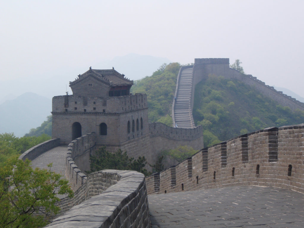
Great Wall of China
The Great Wall of China is a series of stone and earthen fortifications in
northern China, built to delineate political boundaries and to protect the northern borders of the
Chinese Empire against intrusions by various nomadic groups. Several walls
have been built since the 5th century BC that are referred to collectively as
the "Great Wall of China" -- which has been rebuilt and maintained from the 5th century BC
through the 16th century.
The wall originally was estimated to be more than 5,000 kilometers long, but
recent measurements show the total length of the structure may have exceeded 8,000 kilometers.
Due to its rich history and panoramic views, the "Great Wall Of China" is
one of the most visited tourist attractions
in the world, and was designated a UNESCO World Heritage site in
1987. It is
one of the largest building-construction projects ever undertaken, and is still
one of the more remarkable structures on Earth.
(See Jade Gate)
More...
In c. 220 B.C., under Qin Shi Huang,
sections of earlier fortifications were
joined together to form a united defense
system against invasions from the north.
Construction continued up to the Ming
dynasty (1368–1644), when the Great Wall
became the world's largest military
structure. Its historic and strategic
importance is matched only by its
architectural significance.
The Great Wall
actually consists of numerous walls (many of
them parallel to each other) built over some
two millennia across northern China and
southern Mongolia. The most extensive and
best-preserved version of the wall dates
from the Ming dynasty (1368–1644) and runs
for some 5,500 miles (8,850 km) east to west
from Mount Hu near Dandong, southeastern
Liaoning province, to Jiayu Pass west of
Jiuquan, northwestern Gansu province. About
one-fourth of its length consists solely of
natural barriers such as rivers and mountain
ridges.
Note: Some scholars point out that it is a
common misconception that the Great Wall was
originally created in defense against
raiders from the north and east, such as the
Eastern Hu. In fact, the Great Wall was not
conceived to serve a military function until the Qin dynasty, when sections
were added to existing walls. Prior to the Qin, states had long practiced the
construction of walls to delineate political boundaries.
(See
Hsiung-nu
Empire)
Gros
Antoine-Jean Gros When
Napoleon Bonaparte commissioned the 19th century Orientalist painter Baron
Antoine-Jean Gros to
paint "Napoleon Bonaparte Visiting the Plague Victims in Jaffa," Bonaparte
sought to help clear the accusations of the British press who had alleged that
he had wanted to execute the plague-stricken during his retreat to Cairo. The
painting, presented at the 1804 Salon in France, shortly before his coronation -
a particularly opportune moment for Bonaparte - is the first masterpiece of
Napoleonic history painting. Bonaparte and then Napoleon the emperor drew the
painters of the time away from classical subjects and had them paint
contemporary battles and imperial pomp instead, with himself as the heroic
center of attention. Not only is this particular painting a
propaganda masterpiece, it also reflects the complex and hidden motives of some
painters who traveled to the Orient. Another propaganda paintings of the era was
"Napoleon Crossing the Alps." Dominique Vivant, Baron de Denon is
another name often associated with Bonaparte's Egyptian propaganda campaign. Many other individuals were used as instruments of propaganda to
protect France's trade routes and colonies. Bonaparte’s Army of the Orient was
an expeditionary force 54,000 strong. His retinue included 167 engineers,
artists, scientists and journalists named the Commission for Arts and Sciences
(Commission des Sciences et Artes d’Egypte). Their purpose was to catalogue
Egypt’s wonders and promote their discoveries through Bonaparte’s propaganda
machine.
Napoleon's expedition to
Egypt in 1798-1799 led to
the development of Egyptology,
and the acquisition of great collections in prominent museums in the West, by
various means, including looting.
More...
Grunwedel
Albert Grunwedel (1856–1935) was a German indologist, tibetologist archaeologist
and explorer
of Central Asia. Grünwedel was also one of the first scholars to study the
Lepcha language. See IDP
More...
Guangzhou
Cities such as Istanbul, Venice, and Guangzhou were key transportation hubs and trading ports
which could be considered
maritime cities of the Silk Road. Located in southern China on the
Pearl River,
Guangzhou
played a vital role in maritime trade between East and West.
With trade developing
across the Indian Ocean
between
Alexandria in Egypt and
Guangzhou in China, European and Asian
ports became indirectly connected to the caravan routes of the Silk Road.
Gunpowder Fireworks originated in China some 2,000 years ago.
Pure sulfur, the second most
important gunpowder ingredient, was known to
Chinese alchemists as early as the second
century CE. The
dating of gunpowder is as early as 850 A.D.
This invention is said to have been discovered
in China by accident. Gunpowder
has been widely used as a propellant in firearms and as a pyrotechnic
composition in fireworks. During the Sung
Dynasty (960-1276), technology was
highly advanced in fields as diverse as agriculture, iron-working, and printing.
During this period,
military applications of
gunpowder included primitive hand grenades, poisonous
gas shells, flame throwers and land mines
(The term
gunpowder refers broadly to any propellant powder).
More...
Silk Routes.net |
Ipek Yollari.net
