 Silk Road Trade & Travel Encyclopedia
丝绸之路网站(丝路网站)
丝绸之路百科全书—游客、学生和教师的参考资源
İPEK YOLU
ve YOLLARI
ANSİKLOPEDİSİ
一 To Start Your Silk Routes Journey
CLICK
on a Letter from the Alphabetical
Glossary
一
A B
C
D
E
F
G
H I
J
K
L
M
N O P
Q
R
S
T
U V
W
X
Y
Z
Explorers,
Navigation & Mapmaking
Cartography (the study and practice of making
maps).
The earliest known map is a matter of some debate, both because
the definition of "map" is not agreed upon, and because some
artifacts that appear to be maps, might actually not be. A wall painting, which may depict the ancient Anatolian
city of
Çatalhöyük (previously known as Catal Huyuk or Çatal Hüyük
in modern-day Turkey), has been dated to the late 7th millennium
BCE.
More...
Compass (navigation
tool) A compass is a navigational instrument for
determining direction relative to the earth's magnetic poles. The
compass was invented in
ancient China around 247 BCE, and was used for navigation by the
11th century. In addition to compasses and maps, medieval navigation
tools included the
astrolabe, quadrant,
cross-staff, and sextant
(items used to determine
the altitude of the sun
or other celestial
bodies). It was not
until the early 17th
century that the
telescope was first used
for astronomical
purposes.
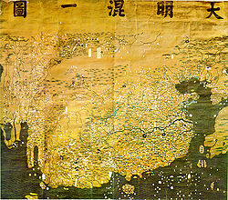
Da Ming Hun Yi Tu is one of the oldest surviving
world maps from East Asia (also known as "The Great Ming Amalgamated Map").
It is a world map produced
in China during the Ming Dynasty. Some scholars believe that the Da Ming Hun Yi Tu was
ultimately based on a world map named Shengjiao Guangbei Tu, which was
created by Li Zemin during the Mongol Yuan Dynasty (a map that is now lost).
More...
Kangnido Map
The Honil Gangni Yeokdae Gukdo Jido ("Map of Integrated Lands and Regions of
Historical Countries and Capitals"), also known as Gangnido (Kangnido), is a
map of the world made in Korea in 1402, the second year of the reign of
Taejong of the newly founded Joseon Dynasty. It is 158.5 cm by 168.0 cm,
painted on silk. The map was created under the supervision of two high
Korean officials, Gim Sahyeong and Yi Hoe, and the Confucian scholar Gwon
Geun. It is the second oldest surviving world map from East Asia, after the
Chinese Da Ming Hun Yi Tu map (part of a Eurasian cartography tradition
begun in the 1320s when geographical information about the West became
available via Islamic geographers in the Mongol empire). The map depicts the
general form of the Old World, from Africa and Europe in the west to Japan
in the east. Although it is less geographically accurate than the early
Chinese world map, it displays some improvements (particularly the
depictions of Korea, Japan, and Africa).
More...
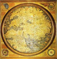
Fra Mauro Map
This map is one of the most important examples of medieval cartography,
made around 1450 by the Venetian monk Fra Mauro. The period of the High
Middle Ages in Europe saw major technological advances, including the adoption
through the Silk Road of printing, gunpowder, the astrolabe, and the compass.
Korean maps such as the Kangnido and Islamic mapmaking seem to have influenced
the emergence of the first practical world maps, such as those of Albertinus De
Virga (made between 1411 and 1415) or Fra Mauro.
More...
Ramusio, a contemporary, states that Fra Mauro's map is "an improved copy of
the one brought from Cathay by Marco Polo." The map made by De Virga presents
locations described in Asia that are consistent with the period of Mongol rule:
Medru, Calcar, Monza sede di sedre ("the Mangi of northern
China"), and Bogar Tartarorum ("the Great Bulgarian" or "Golden Horde").
Regarding the location of Karakorum, fortifications are depicted, with the
mention "M[on]gol." The names shown for Chinese rivers and cities are those used
by Marco Polo. More...
See
History of
Navigation / Age of
Exploration and Discovery
Christopher Columbus: The Quest for Asia from Genoa, to Lisbon, to
Spain & the Americas
Having perfected the astrolabe and quadrant, and developed the lateen-rigged
caravel, it was the Portuguese who led the way of maritime expansion as
Europeans sought alternative routes to Asia. During the Mongol Empire (the
so-called Pax Mongolica, or Mongol peace) Europeans had long
enjoyed a safe land passage along the "Silk Road" to China and India, which were
sources of valuable goods. The maritime expansion of Portugal was the result of
the threat to Mediterranean commerce that had developed very rapidly after the
crusades, especially the trade in spices. Spices traveled by various overland
routes from Asia to the Levant, where they were loaded aboard Genoese and
Venetian ships and brought to Europe. Portuguese navigators, under the
leadership of King John II, sought to reach Asia by sailing around Africa. Major
progress in this quest was achieved in 1488, when Bartolomeu Dias reached the
Cape of Good Hope, in what is now South Africa. Meanwhile, in the 1480s the
Columbus brothers had developed a different plan to reach the Indies (then
construed roughly as all of south and east Asia) by sailing west across the
"Ocean Sea", i.e., the Atlantic. In his quest for Asia, Christopher
Columbus read widely about astronomy, geography, and history, including the
travels of Marco Polo. More...
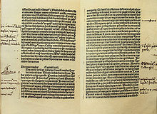
Handwritten notes by
Christopher Columbus on a Latin edition of Polo's book.
Historians have noted that
Christopher Columbus was so inspired by the journeys of the Venetian traveler Marco Polo's description of the
Far East, that he desired to visit those lands for himself. It can be said
that the
Silk Road indirectly
inspired Columbus's voyages to the "New World," as there is evidence Columbus made handwritten annotations on a Latin edition of
Marco Polo's book.
Henry "the Navigator" was a prince of
the Kingdom of Portugal and an important figure in the early days of the
Portuguese Empire. He was responsible for the early development of European
exploration and maritime trade with other continents. He sponsored expeditions
of discovery in the Atlantic Ocean, and down the western coast of Africa. Prince
Henry never actually sailed on any of the voyages of discovery he sponsored.
Instead, he established a school for the study of the arts of navigation,
mapmaking, and shipbuilding, which enabled improved designs and better guidance
for ships. Prince Henry's goal was to find a route to the rich spice trade of
the Indies, while exploring the west coast of Africa. The ships that sailed the
Mediterranean were slow and too heavy to make these voyages. Under his
direction, a new and lighter ship was developed, the caravel, which allowed sea
captains to sail further and faster.
More...
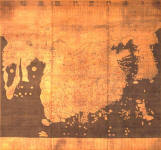
Piri Reis Map of the Americas
Piri Reis was a 16th century Ottoman-Turkish admiral and cartographer. One of
his famous maps is a pre-modern world map dated 1513, which depicts the Western
Hemisphere -- the first surviving map that shows the Americas, including North
America, South America, Greenland, Antarctica, as well as the western coast of
Africa. The map is now preserved in the Topkapi Museum in Istanbul. He has been
credited for depicting parts of the western coasts of Europe and North Africa
with reasonable accuracy. Ottoman Admiral Piri Reis was born on the Gallipoli
Peninsula c.1465, and is an important figure of Turkish naval history. In
addition to creating maps of the Gallipoli Peninsula and the Dardanelles, in
1521 he also wrote a mariner's guide to the coasts and islands of the
Mediterranean ("Book of the Mariner," or "The Naval Handbook"). As he dated his
famous "Map of the Americas," he added this inscription from Gallipoli: "The
author of this is the humble Piri ibn Haji Muhammad, known as the nephew of
Kemal Reis, in the town of Gallipoli in the Holy Month of Muharram of the year
919 [A.D. 1513]."
More...
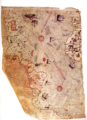
Left fragment of the Piri Reis map showing Central and South
America shores.
In his notes appended to it is written "the map of the western lands drawn by
Columbus."
Silk Routes.net |
Ipek Yollari.net